Friday, May 10, 2013

Kirkwood Post Season

Kirkwood Post Season
5/5/2013
Laure, Quarup, Peter
Two splitboarders and one skier

Kirkwood GPS tracks
The map shows our backcountry route in relation to the regular ski runs.
Two weeks after the Kirkwood ski resort closed for the season, we decided to sneak in for a last run. Officially, Kirkwood does not allow any activity including ski touring after they close for the season. But according to some online forums and some locals, if you do not get in anyone's way, then you're probably okay.

The snow was a bit rotten because it rained the previous night and the slopes were filled with sun cups from the warm weather. As a result, the snow was crumbly and sometimes frustrating to climb. The ride down was a bit bumpy due to the sun cups. We had to cross dirt at the places where snow fully melted near the bottom. That being said, it was still a good exercise and a nice last run at Kirkwood. 

Peter and Laure posing in front of Timber Creek Express.

Round Top

Round Top, Tahoe
5/4/2013
Laure, Quarup, Peter
Two splitboarders and one skier

Round Top GPS tracks
There were dirt patches at the beginning of the trail but once we hit the meadow you could skin all the way to the top. The conditions were firm at the top transitioning to corn and then sticky snow. Overall it was a good day.

Aptly named Crescent Moon couloir, which we did not ski 
About to really start climbing after a fairly flat two mile approach.
Peter sunbathing after skiing down.
Ski pole high five.
Peter's Lhasa Pows filling in for him.

Lassen

Lassen, California
4/13/2013
Laure, Quarup, Peter
Two splitboarders and one skier

Lassen GPS tracks.
As snow in Tahoe receded pretty early this year, we turned to Lassen for a weekend of snow camping. We used an awesome online guide of trails and maps to plan our trip and recommend this website to others planning a ski touring trip in the Cascades.

At the time, roads were completely closed to vehicles beyond both entrances, so we decided to park our car at the southwest entrance's visitor center and tour from there starting at 11am.

The beginning section was plowed but not open for vehicles, so we had to hike it with the gear on our backs. Peter was soon sorry that he had heavy and bulky REI rentals for the backpack, sleeping bag, and sleeping pad.

Laure and Peter hiking the plowed part of the route still closed to vehicles.
You hear that, Elaine? ;-)
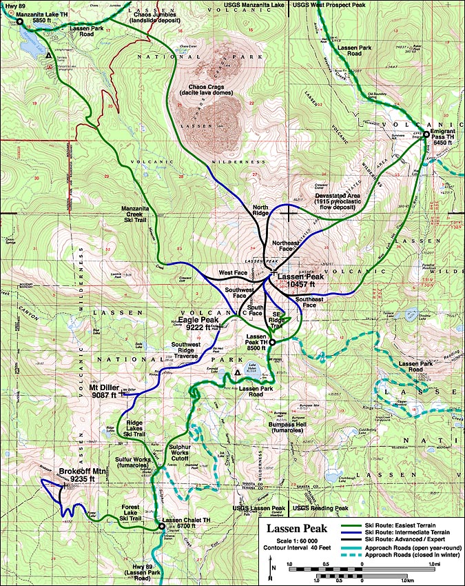
We planned to take a shortcut through the snow named "Sulphur Works Cutoff", which is a more direct route than the road's "U" shape. Unfortunately, we ended up leaving the road too early and got stuck unable to cross one of the sulphur streams. We had to backtrack to the road and decided to play it safe by following the long way instead of trying to take the shortcut. For details, see our GPS tracks above or check out this map to find where the shortcut is.

Peter (with his ridiculous hat), Laure, and Q.
We thought we were taking the Sulphur Works Cutoff.

Agh, you're hurting me!
On our way to Helen Lake, we came across some skiers that gave up on their summit attempt because they heard some whumphing. Later on, Laure also heard some whumphing, which was definitely bad news. Fortunately, we were in a avalanche safe area, but this certainly brewed some concerns about going further the next day.

Helen Lake sits at 8.5k ft above sea level, which was 1.5k ft above our starting point. We reached it at 3:30pm and set up camp shortly before Peter passed out inside. We rented a 4-person 3-season tent from REI, which worked out well.

Our camp near Helen Lake
Lassen Peak
Sunset from Helen Lake
Perhaps the best part of our trip was the amazing backcountry gourmet food that Laure prepared. Among many things, she made couscous with vegetables, mushrooms, and almonds. For breakfast the next day, she made pancakes! The downside is that we carried about 12 pounds of food plus a lot of cooking utensils. But it tasted much better than freeze dried stuff.

Couscous with veggies and mushrooms.
Is that Popeye eating our couscous?
Our plan was to try to summit on the second day. Alas, winds were pretty high (20+ mph) and the first day's whumphing forced us to abandon that idea. Instead, Peter and Q did a short tour of 450 vertical ft before we broke camp and headed back. On our way back, we were able to find the Sulphur Works Cutoff trail that we missed on the way up. We skied and snowboarded down, which turned out to be the best descent of our weekend (see GPS tracks above).

Overall, this was an adventurous trip even though we took it easy on the second day. This was Peter's and Laure's first experience snow camping, so that was a success in itself.


As an added bonus, we were fortunate to catch Chico's showing of the Banff Mountain Film Festival, which was something we had been wanting to do it for a long time. It pumped us up to get into more hardcore adventures.

Tuesday, March 12, 2013

Silver Peak

Silver Peak, Tahoe
3/10/2013
Laure, Quarup, Peter
Two splitboarders and one skier.

Silver Peak GPS tracks.

Awesome day with clear visibility after 10 to 15 inches of new snow from the last storm. Cloud coverage kept temperatures below freezing for about the top two thirds of elevation, which gave us probably the last taste of winter snow before spring comes back in full force. Low avalanche danger with pockets of moderate danger at steep or wind loaded slopes.

We began with our usual late start at 10:45pm, summited at 2:15pm, and got back to car at 5pm. We approached the summit through the northeast ridge, then came back down through the east valley.


Q and Laure following someone's amazing skin track.
Laure, Q, and Peter near a false peak north of the summit.

This has been the most elevation covered for Laure to date: 2,481 ft total. She took the lead and set the pace for most of the climb, which worked out really well for the group.

Peter boot packing south from the false peak towards the summit.
Final push to Silver Peak.
Laure at the summit.
Twin Peaks with KT22 in the foreground.
Photo sphere view of Silver Peak.
We also published it to Google Maps Street View.

We met a few other people including a couple of skiers with a dog named Coda.

We considered skiing down the north east face holding more snow (north of our ascent route) and skin 300 ft back up the ridge. But we took the route that Peter had previously done with Fernando for the sake of safety especially since it was late.

We were happy to find several inches of legitimate powder on the descent.

Laure rooster tailing down Silver Peak.

Peter on a low angle slope down from the peak.

From the peak back to the car, we had to transition to touring mode twice, although it should be possible to go back only transitioning once. Alternatively, if we had more time, then it would have been worth skinning back up farther after the second transition to ride more powder. In any case, we have some good ideas of things to try in the future.

Our tracks were all we left behind.

Saturday, March 9, 2013

Red Lake Peak


Red Lake Peak
3/3/2013
Q, Laure, Elaine, Peter, Dan
Two split boarders, one snowboarder snowshoer, two skiers.

Red Lake Peak attempt GPS tracks.

We climbed 1700 ft to 9100 ft, 900 ft shy of summit. We left the car at 10:30am, turned around at the ridge and started descending at 2pm, and reached the car at 2:40pm.

Setting out for a good day in the backcountry.

Low/moderate avalanche danger. It snowed about 5 inches throughout the day. The snow was a little heavy, especially at the bottom. A little bit of cracking while skinning north face. The temperature was below freezing but not too cold or windy.

Splitboard is the gateway drug to skiing.

We had to do some bushwhacking at the bottom. Three of us got stuck in trees at one point.

Peter, Q, and Dan got chewed out by Elaine for climbing ahead for 20 minutes without reporting back. She blamed it on testosterone.

Tuesday, March 5, 2013

California Chutes

California Chutes
3/2/2013
Q, Laure, and Elanie


California Chutes attempt GPS tracks.

Two split boarders and one snowboarder with snow shoes.  Peter and Dan bailed because they were hungover, and because they bailed they had excellent snow without having to climb up, not to mention the resort was empty.

Mostly clear visibility, low avalanche danger.

Took Kirkwood chair 4 at around 11:30 to tow rope and skinned up.  Traversed and descended a very soft south facing aspect.  Got scared at the sight of the California chutes and turned without descending to Emigrant lake so they could still catch a chair back.

In the meantime Peter and Dan were hunting/killing corn in bounds.  Though because of the lack of people it felt like Peter and Dan were in the backcountry, Peter even had his beacon on.  Dan and Peter found tons of sweet corn in the Palisades where they traversed to because they weren't slowed down by skiers in training and the snowboarder.  Dan and Peter celebrated with a Bloody Mary at the bottom of the lift, while Elaine was tumbling down in the backcountry.

Sunday, March 3, 2013

What's in a name?

Who are the Bognerds and Friends Ski Team?

We are a group of people wanting to log our trip reports with maps, photos, and, best of all, good stories.

Our name is inspired by the company Bogner, which produces products as ridiculous as our stories.

Bogner. Our inspiration.